The Viking wrote:Isn't this ready for at least an idea stamp?
Once you reinstate a little comitment to the map then we'll see about an ideas stamp. For the time being ill be watching
Moderator: Cartographers
![]() by gimil on Thu Aug 07, 2008 8:52 am
by gimil on Thu Aug 07, 2008 8:52 am
The Viking wrote:Isn't this ready for at least an idea stamp?
natty_dread wrote:I was wrong


![]() by CoolC on Thu Aug 07, 2008 2:04 pm
by CoolC on Thu Aug 07, 2008 2:04 pm
The Viking wrote:Have you considered allowing all Baltic Sea Islands to attack each other?


![]() by The Viking on Thu Aug 07, 2008 3:09 pm
by The Viking on Thu Aug 07, 2008 3:09 pm


![]() by Lufsen75 on Tue Aug 12, 2008 2:20 pm
by Lufsen75 on Tue Aug 12, 2008 2:20 pm


![]() by Androidz on Tue Aug 12, 2008 2:56 pm
by Androidz on Tue Aug 12, 2008 2:56 pm


![]() by CoolC on Tue Aug 19, 2008 1:19 pm
by CoolC on Tue Aug 19, 2008 1:19 pm
![]() by Androidz on Tue Aug 19, 2008 1:41 pm
by Androidz on Tue Aug 19, 2008 1:41 pm
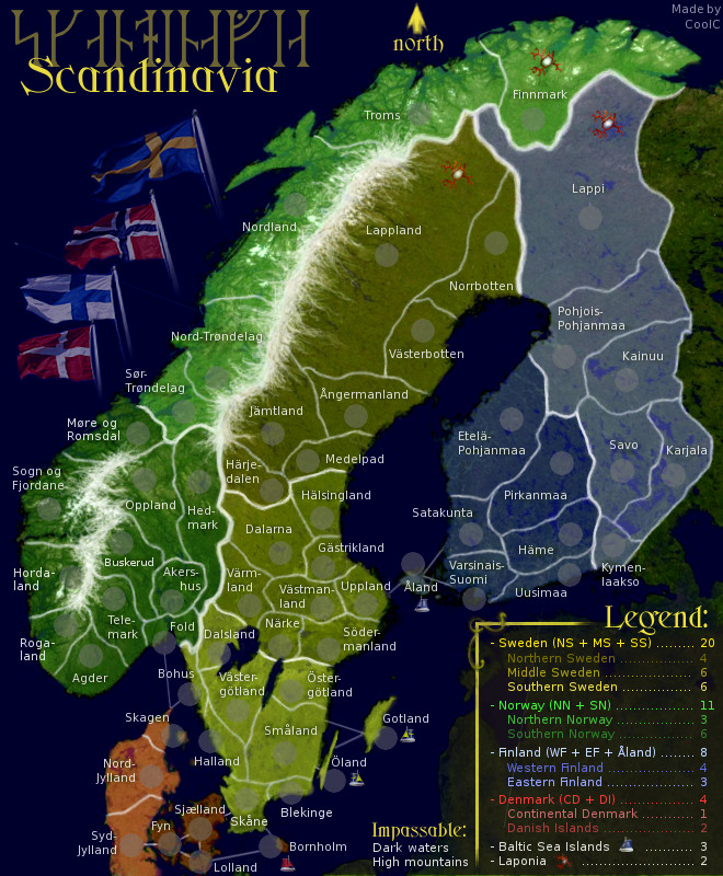
CoolC wrote:Lufsen: I thought it made more sense to have Öland connect to Gotland, it made a chain sort of... but now I've added a link between Småland and Gotland as well. Leaving the connection to Öland since it's reasonable to assume boats can go between the islands...
Regarding the names I've changed to Møre og Romsdal but I insist that Troms is the correct name, for the region. Tromsø is the name of the city. References:
http://sv.wikipedia.org/wiki/Norges_fylken
http://no.wikipedia.org/wiki/Norges_fylker
http://no.wikipedia.org/wiki/Troms
Besides the name and connections mentioned the other changes in version 9 is removal of compass and improval of north arrow and another adjustment of brightness and contrast.
I may reconsider having all islands attack eachother, but I'm not convinced yet...
![]() by Lufsen75 on Tue Aug 19, 2008 3:04 pm
by Lufsen75 on Tue Aug 19, 2008 3:04 pm
CoolC wrote:Lufsen: I thought it made more sense to have Öland connect to Gotland, it made a chain sort of... but now I've added a link between Småland and Gotland as well. Leaving the connection to Öland since it's reasonable to assume boats can go between the islands...
Regarding the names I've changed to Møre og Romsdal but I insist that Troms is the correct name, for the region. Tromsø is the name of the city. References:
http://sv.wikipedia.org/wiki/Norges_fylken
http://no.wikipedia.org/wiki/Norges_fylker
http://no.wikipedia.org/wiki/Troms
Besides the name and connections mentioned the other changes in version 9 is removal of compass and improval of north arrow and another adjustment of brightness and contrast.
I may reconsider having all islands attack eachother, but I'm not convinced yet...
![]() by edbeard on Tue Aug 19, 2008 9:38 pm
by edbeard on Tue Aug 19, 2008 9:38 pm


![]() by CoolC on Wed Aug 20, 2008 1:17 pm
by CoolC on Wed Aug 20, 2008 1:17 pm
edbeard wrote:1. I can't tell with which continent Aland belongs. perhaps put the name above the army circle. It's a bit hard to see what the colour is beneath Fyn on the small map. Maybe try moving the circle and name so that the colour is revealed a bit more.
edbeard wrote:2. The different coloured ships confused me for a minute. How about a white sail for all of them?
edbeard wrote:3. Is there a big significance to the boats (baltic sea islands) and the umm Laponia. What are the Laponia anyway? what's that symbol? They just seem a bit strange. I'm not sure how much they add to the gameplay but it's your map.
edbeard wrote:4. just out of curiosity, how much of this is based on real borders and areas?
![]() by Tense on Mon Sep 08, 2008 5:22 am
by Tense on Mon Sep 08, 2008 5:22 am
![]() by Androidz on Mon Sep 08, 2008 5:59 am
by Androidz on Mon Sep 08, 2008 5:59 am
![]() by Lufsen75 on Wed Sep 10, 2008 12:21 pm
by Lufsen75 on Wed Sep 10, 2008 12:21 pm
Androidz wrote:Here's what i think you should fix:
In the legend denmark is red, now on the map orange. And that makes the legend inaccurate since you have the right colours for the other continents. So you must make the legend orange to when descripeing denmark.
![]() by Androidz on Wed Sep 10, 2008 12:59 pm
by Androidz on Wed Sep 10, 2008 12:59 pm
Lufsen75 wrote:Androidz wrote:Here's what i think you should fix:
In the legend denmark is red, now on the map orange. And that makes the legend inaccurate since you have the right colours for the other continents. So you must make the legend orange to when descripeing denmark.
I dont see that problem. Orange or red could still be called Red on the map.
![]() by MrBenn on Thu Sep 11, 2008 3:30 pm
by MrBenn on Thu Sep 11, 2008 3:30 pm


![]() by MrBenn on Fri Sep 12, 2008 5:38 pm
by MrBenn on Fri Sep 12, 2008 5:38 pm
![]() by CoolC on Sat Sep 13, 2008 6:50 pm
by CoolC on Sat Sep 13, 2008 6:50 pm
![]() by CoolC on Tue Sep 30, 2008 10:46 pm
by CoolC on Tue Sep 30, 2008 10:46 pm
![]() by CoolC on Fri Oct 03, 2008 6:55 pm
by CoolC on Fri Oct 03, 2008 6:55 pm
MrBenn wrote:This map looks very impressive, but I'm not sure if there is enough room for 3-digit army numbers in all the territories... have you checked this yet?
![]() by MrBenn on Sat Oct 04, 2008 2:53 pm
by MrBenn on Sat Oct 04, 2008 2:53 pm
Drafting Room Guidelines wrote:In order for a map to be stamped as having completed the "Draft" stage and moved on to the Main Foundry it must meet the following conditions:
- Relevant details should be summarised in the first post, including the name(s) of the individual(s) responsible for the creation of the map; and any information relevant to how this map will play, including (but not limited to) proposed starting neutral locations and values, victory conditions, unique play features, etc.
- Have a playable image (either large or small map) that fits within the size restrictions; It doesn't have to be perfect, but if the map were quenched today people should be able to play on it. The draft should include:
- territory names
- a working legend
- speculative bonuses
- tentative border divisions
- proposed impassable barriers

![]() by oaktown on Sat Oct 04, 2008 3:05 pm
by oaktown on Sat Oct 04, 2008 3:05 pm
MrBenn wrote:Welcome to the Foundry Proper... onwards and upwards


![]() by CoolC on Sun Oct 05, 2008 8:08 am
by CoolC on Sun Oct 05, 2008 8:08 am
oaktown wrote:And let me be the first to congratulate you... unless I'm fast-posted.
I'll give this a more proper look later, but my first question is what is that thing that's identifying Laponia? Maybe something more attractive and easily identifiable can be found? Reindeer antlers?
CoolC wrote:Laponia is a part of a large national park in northern Sweden and I took the name for a larger area since it's close enough and sounds nice. It's ment to indicate the Sami areas and the symbol is from an old ceremonial drum that belonged to a Sami shaman.
![]() by iancanton on Thu Oct 09, 2008 3:22 am
by iancanton on Thu Oct 09, 2008 3:22 am
CoolC wrote:I've added a link between Småland and Gotland
CoolC wrote:I may reconsider having all islands attack eachother, but I'm not convinced yet...


![]() by Lufsen75 on Tue Oct 28, 2008 8:33 am
by Lufsen75 on Tue Oct 28, 2008 8:33 am
iancanton wrote:sweden is the obvious place where we can merge territories without upsetting the look of the map, perhaps one in the north and one in the south.
ian.
![]() by Ogrecrusher on Tue Oct 28, 2008 5:11 pm
by Ogrecrusher on Tue Oct 28, 2008 5:11 pm
Users browsing this forum: No registered users
|
|||||||
| Conquer Club is not associated with RISK online in any way. Copyright © 2006-2025 by Big Wham LLC | |||||||