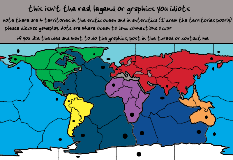
well the arctic is a bit deceiving at the moment without names. There's only four territories in it and only two of those are border territories. One of the border territories connects across the map. When names and circles are there, this confusion will be done.
The same goes for a few pacific ocean territories.
The only place I fuddled this up was in Antarctica. There's meant to be four territories but using the logic of the other areas, I've only made three.
edit I missed your point:
I don't think six is too huge a number. But, not every dot has to be used. EG: you can attack from Alaska to the pacific but not to the arctic and so on
Land and Sea [Quenched]
Moderator: Cartographers
Re: A Real World Map v1p1 gameplay
![]() by edbeard on Tue Jul 15, 2008 12:54 am
by edbeard on Tue Jul 15, 2008 12:54 am
-

 edbeard
- Posts: 2501
- Joined: Thu Mar 29, 2007 12:41 am


Re: A Real World Map v1p1 gameplay
![]() by whitestazn88 on Tue Jul 15, 2008 1:03 am
by whitestazn88 on Tue Jul 15, 2008 1:03 am
edbeard wrote:well the arctic is a bit deceiving at the moment without names. There's only four territories in it and only two of those are border territories. One of the border territories connects across the map. When names and circles are there, this confusion will be done.
The same goes for a few pacific ocean territories.
The only place I fuddled this up was in Antarctica. There's meant to be four territories but using the logic of the other areas, I've only made three.
edit I missed your point:
I don't think six is too huge a number. But, not every dot has to be used. EG: you can attack from Alaska to the pacific but not to the arctic and so on
i didn't realize that the one border territ in arctic connected across the map.
as for the dots not having to be used... then how do you decide which ones get to go where? they just seem way too arbitrary.
it would be fine if you just were like... these are areas that have ports, therefore, they will have access to the water, and design little ports to put on certain places, but at this point, i don't know why alaska should have a connection to the ocean more than california should.
-
whitestazn88
- Posts: 3128
- Joined: Mon Feb 05, 2007 2:59 pm
- Location: behind you


Re: A Real World Map v1p1 gameplay
![]() by edbeard on Tue Jul 15, 2008 1:10 am
by edbeard on Tue Jul 15, 2008 1:10 am
whitestazn88 wrote:i don't know why alaska should have a connection to the ocean more than california should.
edbeard wrote:I chose them based on where land-land and ocean-ocean connections occurred on the map. I thought that was fairly evident. It cuts down on the total number of borders the oceans and lands will have by herding them all into one area. I think this makes for a unique setup as four continents converge in one spot on numerous occasions.
anything I do is FAR from arbitrary
-
edbeard
- Posts: 2501
- Joined: Thu Mar 29, 2007 12:41 am
Re: A Real World Map v1p1 gameplay
![]() by whitestazn88 on Tue Jul 15, 2008 1:17 am
by whitestazn88 on Tue Jul 15, 2008 1:17 am
so i finally understand what you meant about the minimizing borders and stuff, but you still don't explain what you would do to minimize the multiple connections.
as you said, alaska could attack pacific or w/e but not necessarily arctic. how will you choose that?
the river idea is well suited for this map, and i agree, there arent that many, and there would be fewer connections, but i think there are other things we could look at for this.
maybe the great barrier reef could be a point where water and land meet, and the ice shelves in antarctica. you could take it to the extreme and say something like the gold/ivory coasts are literally giant coasts which connect africa to the water
-
whitestazn88
- Posts: 3128
- Joined: Mon Feb 05, 2007 2:59 pm
- Location: behind you
Re: A Real World Map v1p1 gameplay
![]() by edbeard on Tue Jul 15, 2008 1:59 am
by edbeard on Tue Jul 15, 2008 1:59 am
nothing is really set in stone but you haven't convinced me that six places to be attacked is too many for the arctic so I don't really have to make that decision at this moment. if there is a decision to be made, it'll be done with the intention of making the best gameplay for the map. you can't really make one decision at a time. you have to say well if alaska is connected to the pacific then maybe the pacific shouldn't connect to argentina and then the atlantic shouldn't connect with south africa etc...
I don't see any benefit to this river idea when there's probably only three major rivers where this would/could change things on the map. If you consider that ocean-ocean and land-land borders have to be borders for logical and gameplay reasons, there is a benefit to adding other borders (ocean-land) in the same spots so as to not make the map have too many borders for each continent to hold. There's no benefit to saying well the ice shelves make a connection here and the barrier reef makes another one here and finding things to create reasons for gameplay changes.
there's no graphical work occurring on the map at the moment and I suspect that with the Brazil Revamp competition coming up there won't be many artists wiling to work on a new map. So, how these connections will be physically done is up for grabs and I'll probably leave this up to whoever does the graphics. Rivers and canals make for 'nice' ways to say why these connections occur, but when you consider the scale of the map, it might be best just to do double arrows like the Great Lakes map.
-
edbeard
- Posts: 2501
- Joined: Thu Mar 29, 2007 12:41 am
Re: A Real World Map v1p1 gameplay
![]() by whitestazn88 on Tue Jul 15, 2008 2:05 am
by whitestazn88 on Tue Jul 15, 2008 2:05 am
so i suppose all this supposing was useless without a real working image?
-
whitestazn88
- Posts: 3128
- Joined: Mon Feb 05, 2007 2:59 pm
- Location: behind you
Re: A Real World Map v1p1 gameplay
![]() by edbeard on Tue Jul 15, 2008 2:16 am
by edbeard on Tue Jul 15, 2008 2:16 am
well if you were only concerned about graphics then yes it was a waste of your time. I did say on the map itself that these weren't the real graphics and me asking for an artist on there as well is another clue about that.
the draft was done to talk gameplay which we've done a bit. the discussion has affirmed my belief in the gameplay setup though. but, you're only one person and more minds are needed to settle it.
the draft was done to talk gameplay which we've done a bit. the discussion has affirmed my belief in the gameplay setup though. but, you're only one person and more minds are needed to settle it.
-
edbeard
- Posts: 2501
- Joined: Thu Mar 29, 2007 12:41 am
Re: A Real World Map v1p1 gameplay
![]() by oaktown on Tue Jul 15, 2008 2:23 am
by oaktown on Tue Jul 15, 2008 2:23 am
personally I never like it when folks put the arctic/antarctic in their maps... when has a nation ever used the south pole to transport armies, or given a rat's ass about controlling it? e.g. World 2.0. 
-

oaktown
- Posts: 4451
- Joined: Sun Dec 03, 2006 9:24 pm
- Location: majorcommand


Re: A Real World Map v1p1 gameplay
![]() by whitestazn88 on Tue Jul 15, 2008 2:28 am
by whitestazn88 on Tue Jul 15, 2008 2:28 am
oaktown wrote:personally I never like it when folks put the arctic/antarctic in their maps... when has a nation ever used the south pole to transport armies, or given a rat's ass about controlling it? e.g. World 2.0.
technically, its world 2.1...
secondly, it may never be used to transport armies, but many countries nowadays put a big stake in both poles for the research, although thats not really part of the gameplay of this map.
they are also important if you want to have a real map, as edbeard says he does
-
whitestazn88
- Posts: 3128
- Joined: Mon Feb 05, 2007 2:59 pm
- Location: behind you
Re: A Real World Map v1p1 gameplay
![]() by edbeard on Tue Jul 15, 2008 2:32 am
by edbeard on Tue Jul 15, 2008 2:32 am
well the arctic was important to the soviets and their submarines. Didn't you watch 'The Hunt for the Red October' ?
Antarctica isn't really important but it'd feel like a waste not having it. It'd cut down on southern borders for oceans though. It's only included on two of the four 'world' maps we have here. It makes sense in both Extreme Global Warming and World 2.1 for different reasons. EGW because it'd be habitable after the extreme warming. World 2.1 because you NEED a southern attack route (I don't get the 0 bonus though).
Here it's not needed but I think it's a nice touch. Another small continent and if I'm including every other part of the world, why not Antarctica?
The 'real world' title was both used as a way to get people to look at the thread and to describe the lack of a map utilizing both land and sea on the whole world scale. It's not technically meant to say I'm making a 'real' map of the world.
-
edbeard
- Posts: 2501
- Joined: Thu Mar 29, 2007 12:41 am
Re: A Real World Map v1p1 gameplay
![]() by whitestazn88 on Mon Jul 21, 2008 6:15 pm
by whitestazn88 on Mon Jul 21, 2008 6:15 pm
any updates coming soon?
-
whitestazn88
- Posts: 3128
- Joined: Mon Feb 05, 2007 2:59 pm
- Location: behind you
Re: A Real World Map v1p1 gameplay
![]() by Androidz on Mon Jul 21, 2008 6:21 pm
by Androidz on Mon Jul 21, 2008 6:21 pm
You must add big Greenland to your map:O

-

Androidz
- Posts: 1046
- Joined: Mon Dec 03, 2007 11:03 am


Re: A Real World Map v1p1 gameplay
![]() by edbeard on Mon Jul 21, 2008 6:28 pm
by edbeard on Mon Jul 21, 2008 6:28 pm
Androidz wrote:You must add big Greenland to your map:O
it's there. it's the big green mess northeast of North America
it's based on this map http://www.fabiovisentin.com/world_map/ ... ld_map.jpg
-
edbeard
- Posts: 2501
- Joined: Thu Mar 29, 2007 12:41 am
Re: A Real World Map v1p1 gameplay
![]() by Androidz on Mon Jul 21, 2008 6:33 pm
by Androidz on Mon Jul 21, 2008 6:33 pm
edbeard wrote:Androidz wrote:You must add big Greenland to your map:O
it's there. it's the big green mess northeast of North America
it's based on this map http://www.fabiovisentin.com/world_map/ ... ld_map.jpg
hehe i didint see it on your map but now i do:D. im must be blind anyway when giveing bonus for greenland make sure it is a part of denmark;)
-
Androidz
- Posts: 1046
- Joined: Mon Dec 03, 2007 11:03 am
Re: A Real World Map v1p1 gameplay
![]() by whitestazn88 on Fri Jul 25, 2008 5:05 pm
by whitestazn88 on Fri Jul 25, 2008 5:05 pm
so, we getting any updates soon ed?
-
whitestazn88
- Posts: 3128
- Joined: Mon Feb 05, 2007 2:59 pm
- Location: behind you
Re: A Real World Map v1p1 gameplay
![]() by Androidz on Fri Jul 25, 2008 5:12 pm
by Androidz on Fri Jul 25, 2008 5:12 pm
To make it even more intresting. Is to make an old Version of the the World map. When the roman empire was at it largest, or Prussia. or something else....
-
Androidz
- Posts: 1046
- Joined: Mon Dec 03, 2007 11:03 am
Re: A Real World Map v1p1 gameplay
![]() by whitestazn88 on Fri Jul 25, 2008 5:16 pm
by whitestazn88 on Fri Jul 25, 2008 5:16 pm
no way man... an old version of the world map would be ineffective, as he would have to accurately portray the poor means of travel on water... which would make holding ocean territs extremely easy
-
whitestazn88
- Posts: 3128
- Joined: Mon Feb 05, 2007 2:59 pm
- Location: behind you
Re: A Real World Map v1p1 gameplay
![]() by Androidz on Fri Jul 25, 2008 5:20 pm
by Androidz on Fri Jul 25, 2008 5:20 pm
i dont think it will be as you say, diffrences is small and that wont happend. but makeing a world map of the modern world is to close as W2.1 better to use something more old.
-
Androidz
- Posts: 1046
- Joined: Mon Dec 03, 2007 11:03 am
Re: A Real World Map v1p1 gameplay
![]() by edbeard on Fri Jul 25, 2008 5:41 pm
by edbeard on Fri Jul 25, 2008 5:41 pm
as for updates, there's been no discussion so any updates would be based solely on my own thoughts. I'd rather see what other people say about borders and bonuses. Only one guy (you) really talked about the map and that's not enough to come to a consensus.
after the brazil revamp competition, I'll make a poll about interest and I'll try to see if there are any artists interested in doing the graphics.
on the slim chance that there's multiple people interested I might even hold a mini-competition where people would show an inkling of their take on the graphics.
it's easier for people to talk about the map when they can see something with good graphics.
-
edbeard
- Posts: 2501
- Joined: Thu Mar 29, 2007 12:41 am
Re: A Real World Map v1p1 gameplay
![]() by Juan_Bottom on Fri Jul 25, 2008 10:32 pm
by Juan_Bottom on Fri Jul 25, 2008 10:32 pm
If the map on page one is the concept:
This guy is not a fan of all the funny border angles in the ocean territories. Make them boxes like Axis and Allies. Also, it sees to be very similer to the classic map, but with oceans too.
Is the Mediteranian included?
This draft is ok, but I'm not all too excited myself, just yet. The classic with oceans kinda throws me off a bit.
-

Juan_Bottom
- Posts: 1110
- Joined: Mon May 19, 2008 4:59 pm
- Location: USA RULES! WHOOO!!!!


Re: A Real World Map v1p1 gameplay
![]() by InkL0sed on Sun Aug 24, 2008 9:47 pm
by InkL0sed on Sun Aug 24, 2008 9:47 pm
Ed, do the graphics yourself. I actually rather like that as a first draft...
-

InkL0sed
- Posts: 2370
- Joined: Sat Jun 23, 2007 4:06 pm
- Location: underwater


Re: A Real World Map v1p1 gameplay
![]() by edbeard on Sun Aug 24, 2008 9:58 pm
by edbeard on Sun Aug 24, 2008 9:58 pm
at the moment I'll say no but if by a miracle this map gets a lot of interest yet no one willing to do the graphics, I'll tough it out.
Right now I'd rather discuss gameplay. The first thing to figure out is land/water connections. As someone said, if I make all the dots (in the same general area) as connections then that's probably too many attack routes.
so, It'll probably be something like SE Pacific connects to Argentina but not Antarctica. While the SW Atlantic touches Antarctica but not Argentina. Furthermore, this means that the East Pacific territory would border Central America and not Colombia and Midwest Atlantic would border Colombia but not Central America.
I could go through and use that logic throughout but I'll do that later. Esp if people think it's a good idea.
Someone asked about the Mediterranean. It's not going to be in the map because size and spacing is already an issue. I don't even know if these territories are good ones or not or if I should rework some of them or get rid of some or add some whatever. I think I have 51 territories but I need to count them (if you're going to do this note that while there are 4 arctic ocean territories, there are also 4 antarctica territories (only because I screwed up the borders there) and territories in the pacific cross over the sides of the map. This will be represented by having army circles on one side and names on the other and probably a note in the legend about this too).
Right now I'd rather discuss gameplay. The first thing to figure out is land/water connections. As someone said, if I make all the dots (in the same general area) as connections then that's probably too many attack routes.
- Click image to enlarge.
so, It'll probably be something like SE Pacific connects to Argentina but not Antarctica. While the SW Atlantic touches Antarctica but not Argentina. Furthermore, this means that the East Pacific territory would border Central America and not Colombia and Midwest Atlantic would border Colombia but not Central America.
I could go through and use that logic throughout but I'll do that later. Esp if people think it's a good idea.
Someone asked about the Mediterranean. It's not going to be in the map because size and spacing is already an issue. I don't even know if these territories are good ones or not or if I should rework some of them or get rid of some or add some whatever. I think I have 51 territories but I need to count them (if you're going to do this note that while there are 4 arctic ocean territories, there are also 4 antarctica territories (only because I screwed up the borders there) and territories in the pacific cross over the sides of the map. This will be represented by having army circles on one side and names on the other and probably a note in the legend about this too).
-
edbeard
- Posts: 2501
- Joined: Thu Mar 29, 2007 12:41 am
Re: Land And Water v2p4 gameplay talk
![]() by edbeard on Sat Sep 06, 2008 10:31 pm
by edbeard on Sat Sep 06, 2008 10:31 pm
- Click image to enlarge.
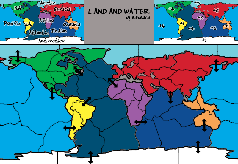
What you need to know:
1. 51 territories (31 land and 20 water)
2. 10 continents
1. decided to put in a workable legend (though I didn't put any thought into bonuses so please rip em to shreds) which had the side effect of making the image very very ugly
2. decided to put in arrows to make land-water connections so gameplay could be discussed (though I didn't put too much thought into them so please rip em to shreds) which had the side effect of making the image very very ugly
-
edbeard
- Posts: 2501
- Joined: Thu Mar 29, 2007 12:41 am
Re: Land And Water v2p4 gameplay talk
![]() by InkL0sed on Sat Sep 06, 2008 11:15 pm
by InkL0sed on Sat Sep 06, 2008 11:15 pm
I think the ocean-water connections should be based on what's convenient for game play.
And I think arrows are a move in the right direction for indicators, although these obviously don't look to great.
Also, I wouldn't mind doing the graphics for this, though I don't know that I'm any better than you...
And I think arrows are a move in the right direction for indicators, although these obviously don't look to great.
Also, I wouldn't mind doing the graphics for this, though I don't know that I'm any better than you...
-
InkL0sed
- Posts: 2370
- Joined: Sat Jun 23, 2007 4:06 pm
- Location: underwater
Re: Land And Water v2p4 gameplay talk
![]() by edbeard on Sat Sep 06, 2008 11:22 pm
by edbeard on Sat Sep 06, 2008 11:22 pm
right now I'm not worrying about graphics at all (though I'd rather get someone experienced (no offense)). I mean the legend is awful looks-wise but it's just a starting point to get gameplay talk going (I think going for a 'black and white' (greys) look would be a lot better).
thoughts on the continents?
thoughts on where the land-water connections occur? I'd like to get one from Arctic to Eurasia in there but that'd throw off all the other connections. maybe it'd be better to start with connections that we all feel are 'necessary' and then add other ones that makes sense after that.
only ones I feel are 'necessary'
1. India - North Indian Ocean
2. NE Atlantic - NW Africa
all the others I have no real affection.
-
edbeard
- Posts: 2501
- Joined: Thu Mar 29, 2007 12:41 am
Who is online
Users browsing this forum: No registered users
|
|||||||
| Conquer Club is not associated with RISK online in any way. Copyright © 2006-2025 by Big Wham LLC | |||||||